


 January 18, 2016
1602
January 18, 2016
1602
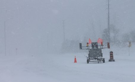
Snow squalls will continue Monday night. Snowfall rates of five centimetres per hour are possible under the strongest bands. Additionally, strong and gusty northwest winds may carry the snow squalls well inland, resulting in areas of blowing snow. Sudden nil visibility in blowing snow and bursts of heavy snow are likely.
Total snowfall amounts could be significant. To the lee of Lake Huron, most likely in a swath between Kincardine and Goderich southeast to near Listowel to Palmerston, total snowfall accumulations could reach 40 to 80 centimetres.
Dangerous winter driving conditions, with frequent nil visibility in white-out conditions from blowing snow and bursts of heavy snow, are expected. Travel is not recommended.
The snow squalls may persist into Tuesday in this longer-lived event, although they are expected to shift their orientation and weaken somewhat beginning late Monday evening.
Snow squalls cause weather conditions to vary considerably; changes from clear skies to heavy snow within just a few kilometres are common. Visibility will be suddenly reduced to near zero at times in heavy snow and blowing snow. Travel is expected to be hazardous due to reduced visibility. If visibility is reduced while driving, slow down, watch for tail lights ahead and be prepared to stop. Rapidly accumulating snow could make travel difficult over some locations.

Blowing and drifting snow almost obliterates the road-closed sign, on Highway 21, at the south end of Kincardine, beside Superheat FGH, looking north, Monday morning

Blowing and drifting snow beside Superheat FGH, at the south end of Kincardine, Monday morning

Blowing and drifting snow along Highway 21, beside Superheat FGH, looking south, Monday morning
Written ByLiz Dadson is the founder and editor of the Kincardine Record and has been in the news business since 1986.
Related Stories
No related stories.